
Bestaand:Carleton Coon races after Pleistocene.PNG
Oorsprungelik bestand (1.357 × 628 bealdpunten, bestandsgroutde: 36 kB, MIME-type: image/png)
Beskryving
| Beskryving |
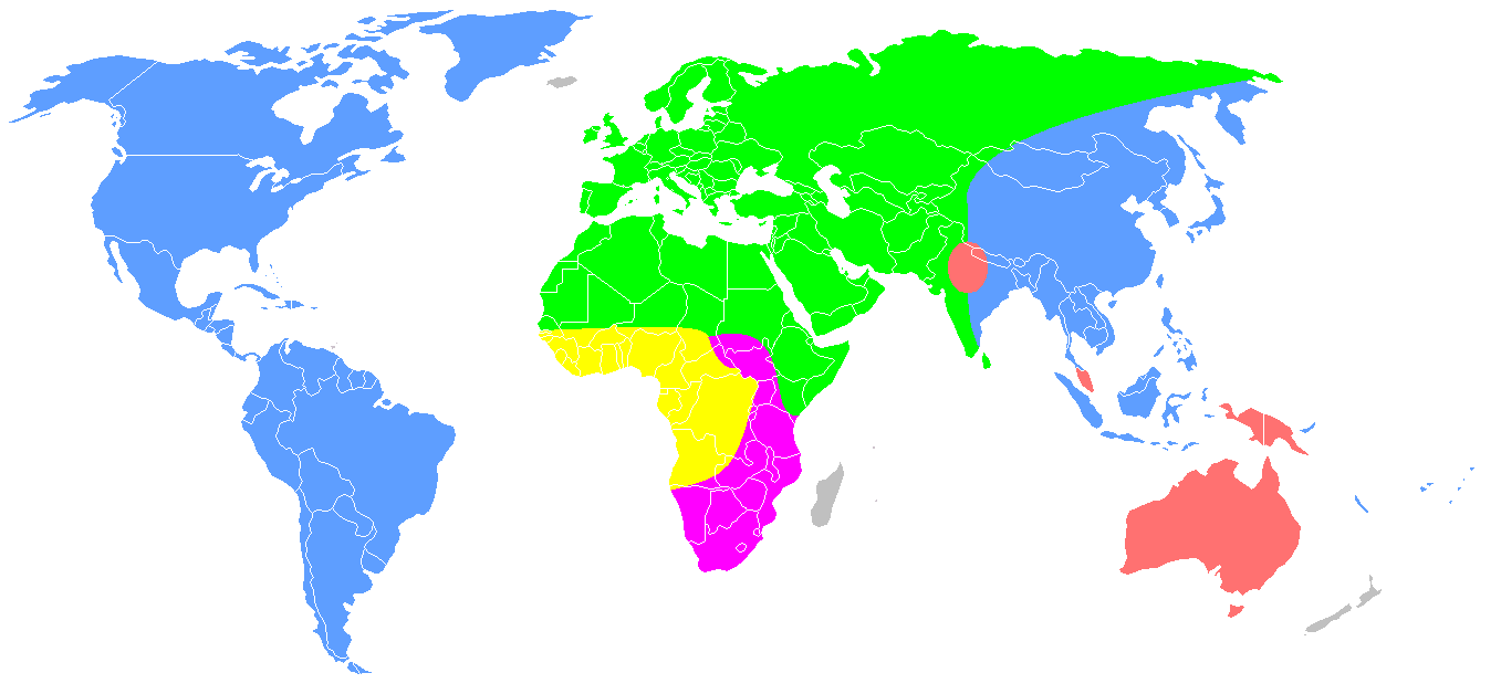
English: Redrawing of a map from Carleton S. Coon, The Origin of Races (1962), p. 659.
Distribution of Coon's "five geographical races of man" after the end of the Pleistocene. This is the second of the two maps numbered "Map 13", labelled "Early Post-Pleistocene". Original caption: "The second map shows what happened at the end of the Pleistocene, when the Mongoloids and Caucasoids expanded and burst out of their territories. The Mongoloids entered and inhabited America, and extended their domain southward into Southeast Asia and Indonesia, while the Australoids crossed Wallace's Line and occupied Australia and New Guinea. The Caucasoids thrust northward. More significantly, they drove the Capoids out of North Africa and occupied the White Highlands of Kenya and Tanganyika. The Congoids were reduced to a small part of their earlier domain, including the Congo forests and the lands to the north, where they later evolved rapidly and spread, as Negroes, over much of Africa." Some of these hypotheses are no longer tenable, it is now known that the Proto-Australoid peopling of Australia is much earlier, and that the Capoids developed in South, not North Africa.
|
| Dåtum | 1 oktober 2007 (originele uploaddatum) |
| Bron | Verplaatst vanaf en.wikipedia naar Commons. free-use map of the world from Wikipedia Commons. "The living Races of Man"[1][2] |
| Autöör | Dark Tea op de Engelstalige Wikipedie |
| Aandere versies |
 |

|
Deze biogeographical map-afbeelding zou opnieuw moeten worden aangemaakt als een SVG-bestand door vectorafbeeldingen te gebruiken. Dit heeft een aantal voordelen; zie Commons:Media for cleanup voor meer informatie. Als er een SVG-formaat van deze afbeelding bestaat, dan deze graag uploaden. Nadat u dit heeft gedaan, gelieve dit sjabloon te vervangen door het sjabloon {{vector version available|nieuwe bestandsnaam.svg}} op deze afbeeldingspagina.
|
Legend
| Australoids | ||
| Mongoloids | ||
| Caucasoids | ||
| Capoids | ||
| Congoids |
Licensy

|
Der wördt tostemming geaven vöär et kopieren, verspreiden en/of wysigen van dit dokument under de vöärwaerden van de GNU-licensy vöär vrye dokumentaty, versy 1.2 of een latere versy so as uutgeaven döär de Free Software Foundation; sunder unveranderlike sektys, sunder ümslagteksten vöär of achter. Een kopy van de licensy is upnöämen in de sekty GNU-licensy vöär vrye dokumentaty. |
- Jy möäget:
- üm te deylen – et wark kopieren, verspreiden en döärgeaven
- üm te hermengen – et wark anpassen
- Under de volgende vöärwaerden:
- naamsvermelding – Jy müttet up en nette manere an naamsvermelding doon, en verwysing nå de licensy geaven en angeaven of der anpassingen dån bint. Jy möäget dit up elke readelike manere doon, mär neet up sou'n manere dat et de indrük wekt dat de lincensyholder juw wark understöänt of juw gebruuk van syn wark.
- lyke deylen – As jy materiaal menget, veranderet, of derup voordbouwet, dan müt jy juw bydragen verspreiden under deselvde of een vergelykbåre licensy as de oorsprungelike.
Oorspronkelik logboek mit nieje bestaanden
- 2007-10-01 10:13 Dark Tea 1357×628×8 (48426 bytes) This is a recreation of Carleton Coon's racial map [http://www.snpa.nordish.net/index2.htm source]. It is made from a free-use image of the world found on Wikipedia. It is made to replace the previous I made which was innacurate.--~~~~
- ↑ https://www.jstor.org/stable/2740426?seq=1#page_scan_tab_contents
- ↑ https://archive.org/stream/B-001-001-289#page/n567/mode/2up
Bestandsgeskydenisse
Klik up een datum/tyd üm et bestand te seen so as et destyds was.
| Datum/tyd | Miniatuurafbealding | Groutde | Gebruker | Kommentaar | |
|---|---|---|---|---|---|
| aktueel | 12:20, 19 okt 2020 | | 1.357 × 628 (36 kB) | Bidgee | Reverted to version as of 09:48, 19 October 2020 (UTC) Enough! COM:OVERWRITE is there for a reason and is on the very page used to upload and revert. Please stop. |
| 12:10, 19 okt 2020 |  | 1.357 × 628 (35 kB) | Intonraiha | ? I have already included a new reference. Read it. | |
| 11:48, 19 okt 2020 |  | 1.357 × 628 (36 kB) | Rsk6400 | Reverted to version as of 19:22, 25 September 2020 (UTC) - See Discussion, section "South Asia". If you have a better source, name it on the discussion page. | |
| 11:01, 19 okt 2020 |  | 1.357 × 628 (35 kB) | Intonraiha | It is not sourced. The source does support this map. As others have discussed in the talk page. The references clearly mention the border as with in this version. It is not about Coons first version. | |
| 21:55, 18 okt 2020 |  | 1.357 × 628 (36 kB) | Rsk6400 | Reverted to version as of 19:22, 25 September 2020 (UTC) - This version corresponds to Coon's original version | |
| 21:58, 9 okt 2020 |  | 1.357 × 628 (35 kB) | BoxofPandoraisopened | Restoring cited version. If we use such a map, we should use the version which Coon ultimately proposed and not a prototype version. | |
| 21:22, 25 sep 2020 |  | 1.357 × 628 (36 kB) | Fæ | Reverted to version as of 09:48, 25 September 2020 (UTC) Restore, per File:The Origin of Races, map 13 (IA B-001-001-289).jpg. Please avoid adding user interpretations when the published 1962 map can be directly referenced. | |
| 21:04, 25 sep 2020 |  | 1.357 × 628 (34 kB) | Fylindfotberserk | I'm restoring the south Asian part as per "Living Races Of Man" and "The Origin of Races", plains of Assam (Brahmaputra) and Bengal are settled by Caucasoids. page 485 of "The Origin of Races" writes "Caucasoid and Mongoloid had a common border at the "Edges of the Assam and Bengal plains." | |
| 11:48, 25 sep 2020 |  | 1.357 × 628 (36 kB) | Fæ | Reverted to version as of 14:58, 10 March 2018 (UTC) removing the changes of multiple sockpuppet accounts | |
| 03:06, 15 aug 2019 |  | 1.357 × 628 (35 kB) | LenguaMapa | Reverted to version as of 19:07, 1 July 2019 (UTC) revert back (this is after pleistocene...) |
.jpg&action=edit&redlink=1)
Bestandsgebruuk
Geen enkele syde gebruukt dit bestand.
Globaal bestandsgebruuk
De volgende andere wikis gebruken dit bestand:
- Gebruuk up bg.wikipedia.org
- Gebruuk up en.wikipedia.org
- Gebruuk up es.wikipedia.org
- Gebruuk up fr.wikipedia.org
- Gebruuk up hr.wikipedia.org
- Gebruuk up it.wikipedia.org
- Gebruuk up ml.wikipedia.org
- Gebruuk up no.wikipedia.org
- Gebruuk up tl.wikipedia.org
- Gebruuk up uk.wikipedia.org