
Bestaand:Frankish Empire 481 to 814-nl 2.svg

Afmetingen van deze voorvertoning van het type PNG van dit SVG-bestand: 800 × 566 bealdpunten Andere resolutys: 320 × 226 bealdpunten | 640 × 453 bealdpunten | 1.024 × 724 bealdpunten | 1.280 × 905 bealdpunten | 2.560 × 1.810 bealdpunten | 1.735 × 1.227 bealdpunten.
Oorsprungelik bestand (SVG-bestand, uutgangsgroutde 1.735 × 1.227 bealdpunten, bestandsgroutde: 332 kB)
Beskryving
| Beskryving |
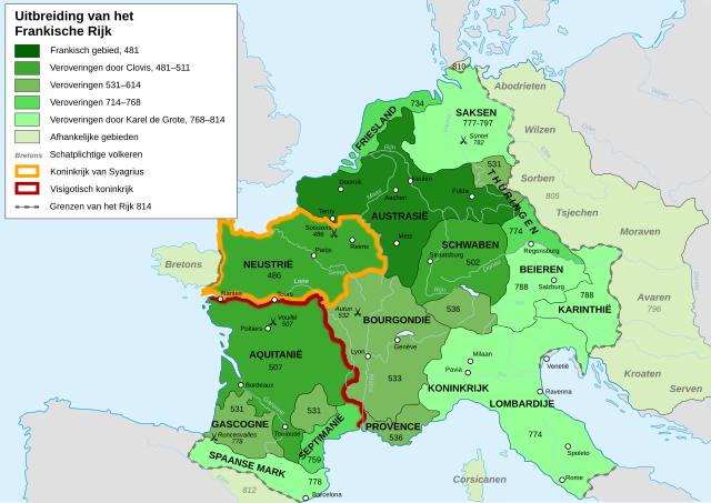
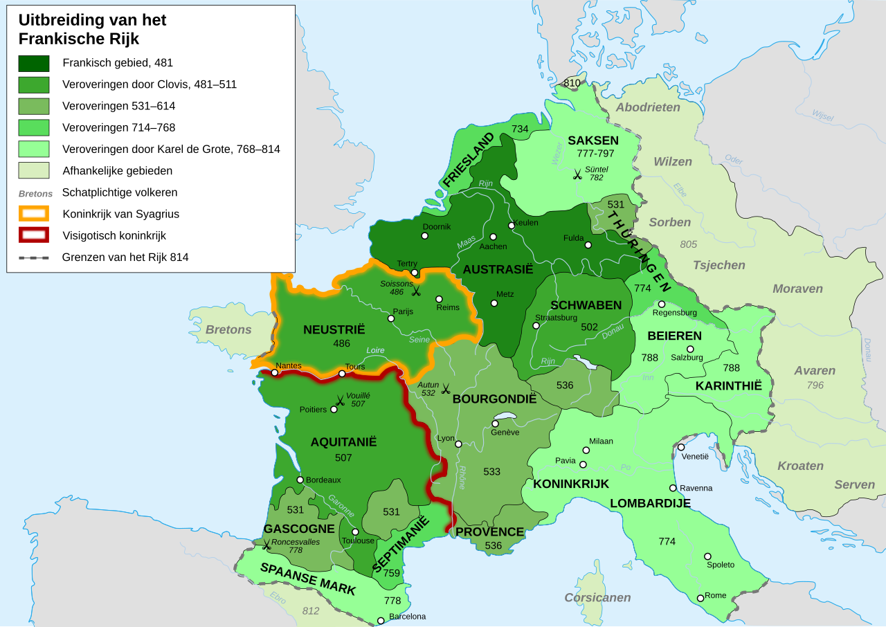
[] Afrikaans: Die veranderende strekking van die Frankiese Ryk van 481 tot 814. Alemannisch: S Frankeriich vo 481 bis 814. Bahasa Indonesia: Peta kebangkitan Kekaisaran Franka, dari tahun 481 hingga 814. Català: Mapa de l'expansió de l'Imperi Franc, de 481 a 814. Deutsch: Karte der Ausdehnung des Fränkischen Reichs 481 bis 814. English: Map of the rise of Frankish Empire, from 481 to 814. Español: Mapa de la expansión del Imperio Franco, entre 481 y 814. Euskara: Frankoen Inperioaren hedapenaren mapa, 481-814 urteen bitartean. Français : Carte de l'expansion de l'empire Franc, entre 481 et 814. Italiano: Carta dell'espansione dell'impero dei Franchi tra il 481 e il 814. Magyar: Frank Birodalom 481-814 Nederlands: Kaart van de opkomst van het Frankische Rijk, van 481 tot 814. Polski: Mapa rozwoju Imperium Franków w latach 481-814 Português: Mapa da expansão do Império Franco, entre 481 e 814. Română: Harta ascensiunii Imperiului franc, 481-814. Svenska: Karantanien i det frankiska riket (år 788 - 843). Ελληνικά: Η Φραγκική Αυτοκρατορία 481-814 Македонски: Карта на подемот на Франкското царство, од 481 до 814 г. Русский: Карта расширения империи франков, между 481 и 814. Українська: Карта розширення імперії Франків в період 481-814 рр. 日本語: カロリング朝の版図。 中文: 墨洛温王朝到加洛林王朝(481—814)的法兰克王国。 العربية : إمبراطوريَّة الفرنجة ما بين عاميّ 481 و814م |
| Dåtum | |
| Bron | File:Frankish Empire 481 to 814-de.svg, itself from from the Historical Atlas by William R. Shepherd (Shepherd, William. Historical Atlas. New York: Henry Holt and Company, 1911.) |
| Autöör | Druifkes |
| Aandere versies |
[]
|
Licensy
Ik, de autöörsrechtholder van dit wark, geave disse media uut under de volgende licensy:
Dit bestand valt under de Creative Commons-licensy Naamsvermelding-Lyke deylen 3.0 neet porteerd
- Jy möäget:
- üm te deylen – et wark kopieren, verspreiden en döärgeaven
- üm te hermengen – et wark anpassen
- Under de volgende vöärwaerden:
- naamsvermelding – Jy müttet up en nette manere an naamsvermelding doon, en verwysing nå de licensy geaven en angeaven of der anpassingen dån bint. Jy möäget dit up elke readelike manere doon, mär neet up sou'n manere dat et de indrük wekt dat de lincensyholder juw wark understöänt of juw gebruuk van syn wark.
- lyke deylen – As jy materiaal menget, veranderet, of derup voordbouwet, dan müt jy juw bydragen verspreiden under deselvde of een vergelykbåre licensy as de oorsprungelike.

|
Der wördt tostemming geaven vöär et kopieren, verspreiden en/of wysigen van dit dokument under de vöärwaerden van de GNU-licensy vöär vrye dokumentaty, versy 1.2 of een latere versy so as uutgeaven döär de Free Software Foundation; sunder unveranderlike sektys, sunder ümslagteksten vöär of achter. Een kopy van de licensy is upnöämen in de sekty GNU-licensy vöär vrye dokumentaty. |
Jy möäget selv eyn van de licensys kesen.
Bestandsgeskydenisse
Klik up een datum/tyd üm et bestand te seen so as et destyds was.
| Datum/tyd | Miniatuurafbealding | Groutde | Gebruker | Kommentaar | |
|---|---|---|---|---|---|
| aktueel | 12:48, 25 aug 2013 | | 1.735 × 1.227 (332 kB) | Qwertyus | "met een verplichte afdracht" → "schatplichtig" (Dutch word for tributary) |
| 12:45, 25 aug 2013 |  | 1.735 × 1.227 (332 kB) | Qwertyus | Corrected grammar and names (of Slavic tribes in particular). | |
| 15:45, 4 mrt 2009 |  | 1.735 × 1.227 (332 kB) | Druifkes | {{Information |Description={{nl|1=Map van het Frankische Rijk Map of the Frankish Empire}} |Source=File:Frankish Empire 481 to 814-blank.svg, itself from from the Historical Atlas by William R. Shepherd (Shepherd, William. Historical Atlas. New York: Henr |
Bestandsgebruuk
Dit bestand wördt up de volgende 2 syden gebruked:
Globaal bestandsgebruuk
De volgende andere wikis gebruken dit bestand:
- Gebruuk up de.wikipedia.org
- Gebruuk up nl.wikipedia.org