
Bestaand:Geological map Britain William Smith 1815.jpg
Oorsprungelik bestand (1.200 × 1.769 bealdpunten, bestandsgroutde: 456 kB, MIME-type: image/jpeg)
| Beskryving |
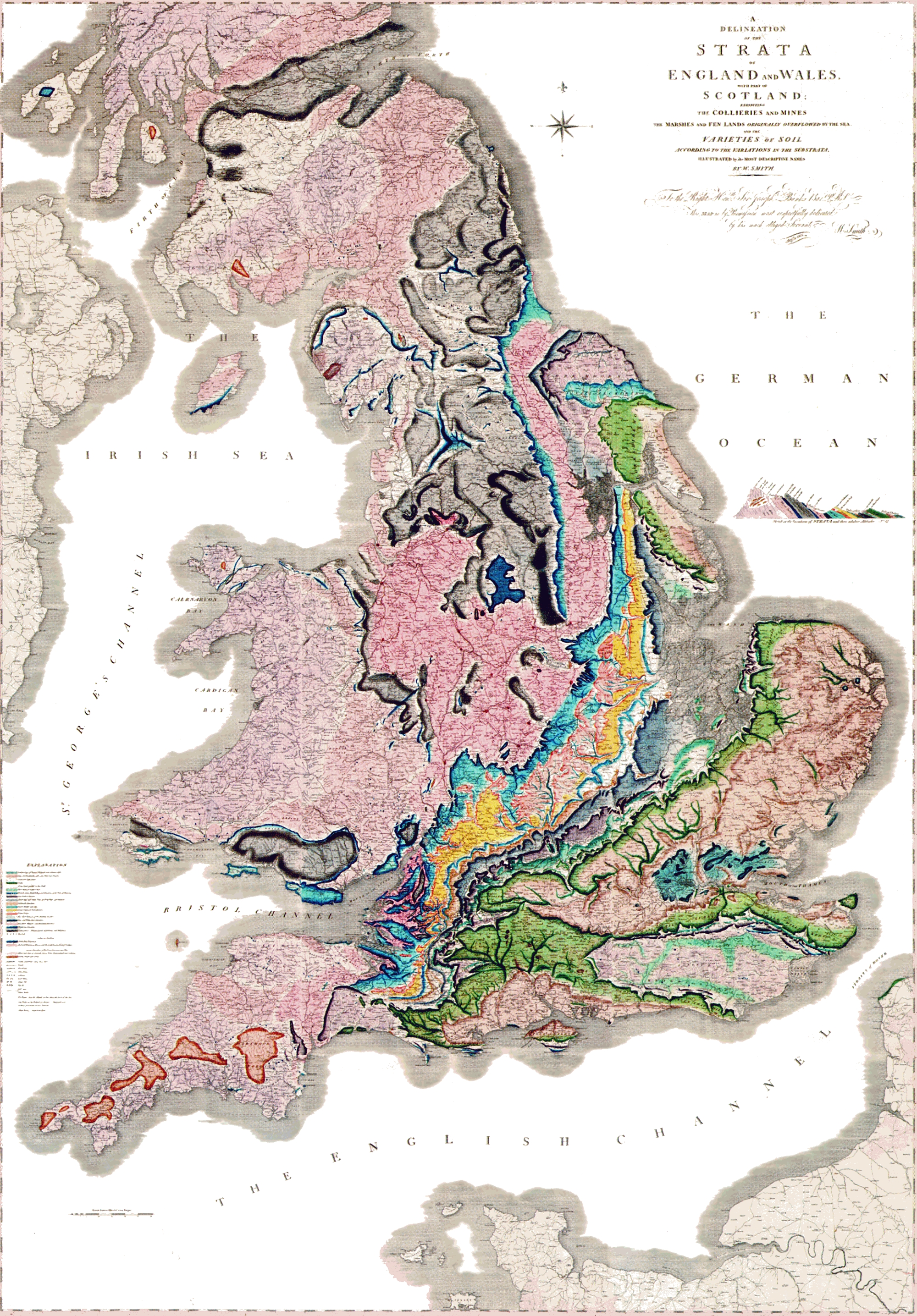
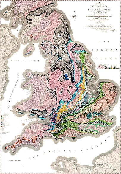
A delineation of the strata of England and Wales with part of Scotland. (The first geological map of Britain, published by William Smith in 1815) |
|||||
| Dåtum | ||||||
| Bron |
Onbekend العربية: خريطةُ وليام سميث الجيولوجية لإنجلترا وويلز وجنوب اسكتلندا، والتي تم الانتهاء منها في عام 1815م، وتُعتبر ثاني خريطة جيولوجيّة على النطاق الوطني، وكانت أدقَّ خريطةٍ في وقتها |
|||||
| Autöör | William Smith (1769-1839) | |||||
| Tostemming (Hergebruuk van dit bestand) |
|
|||||

Bestandsgeskydenisse
Klik up een datum/tyd üm et bestand te seen so as et destyds was.
| Datum/tyd | Miniatuurafbealding | Groutde | Gebruker | Kommentaar | |
|---|---|---|---|---|---|
| aktueel | 23:03, 29 mei 2024 | | 1.200 × 1.769 (456 kB) | Anticline | Reverted to version as of 00:45, 11 December 2008 (UTC) as this image more accurately reflects the colouring and appearance of the map |
| 16:45, 20 okt 2014 |  | 2.000 × 2.871 (4,63 MB) | Ivtorov | edited colors, crop. | |
| 02:45, 11 dec 2008 |  | 1.200 × 1.769 (456 kB) | Gump Stump | {{Information |Description=The first geological map of Britain, published by William Smith in 1815. |Source=[http://www.livescience.com/php/multimedia/imagedisplay/img_display.php?pic=051031_first_map_02.jpg LiveScience Image Gallery] Scan by the Library |
Bestandsgebruuk
Dit bestand wördt up de volgende syde gebruked:
Globaal bestandsgebruuk
De volgende andere wikis gebruken dit bestand:
- Gebruuk up ar.wikipedia.org
- Gebruuk up bg.wikipedia.org
- Gebruuk up bn.wikipedia.org
- Gebruuk up ca.wikipedia.org
- Gebruuk up de.wikipedia.org
- Gebruuk up en.wikipedia.org
- Gebruuk up es.wikipedia.org
- Gebruuk up fr.wikipedia.org
- Gebruuk up fy.wikipedia.org
- Gebruuk up gl.wikipedia.org
- Gebruuk up he.wikipedia.org
- Gebruuk up hy.wikipedia.org
- Gebruuk up it.wikipedia.org
- Gebruuk up ja.wikipedia.org
- Gebruuk up ka.wikipedia.org
Globaal gebruuk van dit bestand bekyken.